UK seas sizzling with extreme 5°C heat spike as Super El Niño looms
Large areas of the Atlantic Ocean and Mediterranean Sea are currently 5°C (9°F) hotter than they usually are, which weather boffs say is a red flag that the burst of piping hot weather will be here imminently.

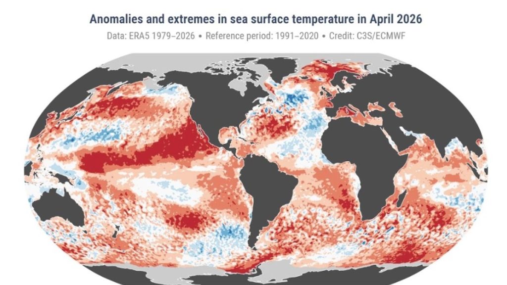
El Nino directly impacts sea surface temperatures(Image: Copernicus Climate Change Service, European Centre for Medium-Range Weather Forecasts)
The seas are warming up in an indication that the Super El Nino heatwave is about to hit. Large areas of the Atlantic Ocean and Mediterranean Sea are currently 5°C (9°F) hotter than they usually are, which weather boffs say is a red flag that the burst of piping hot weather will be here imminently.
Weather experts have been studying satellite imaging of the seas and skies to keep a check on what is coming in the next few weeks, amid warnings the extreme weather event will hit soon. They show an ongoing marine heatwave off the northern and western coasts of France as well as the southern coast of Spain and in the sea off Monaco.
British waters have also been affected with the seas off the coast of Dover, Eastbourne and Brighton also significantly warmer than they usually would be at this time of year. In some underwater areas, satellites show areas of dark red indicating soaring temperatures beneath the surface.
The image is based on recorded sea surface temperatures on 30 May, provided by the Copernicus Marine Service.
The ‘Super El Niño’ – marked by sustained warm temperatures across the Pacific Ocean – is inching closer with experts from the World Meteorological Organisation (WMO) saying they believe there is an 80% likelihood of the weather phenomenon occurring during the three month summer period of June to August.
Current signs point to this year being one of the strongest El Niño patterns ever recorded with extreme heat expected to hit ‘nearly everywhere’ across the world with global average temperatures expected to rise by as much as 3°C (5.4°F) this summer alone.
El Niño years form part of a natural cycle known as the El Niño–Southern Oscillation and are marked by sustained warm temperatures across the Pacific Ocean. Where this ocean surface warming exceeds 2°C (3.6°F), the event is often referred to as a ‘super El Niño’.
Acientists say there’s a strong chance 2026 will be the hottest year ever recorded, which would break the record set in 2024, when global warming exceeded 1.5°C (2.7°F) above the pre–industrial average for the first time..
WMO Secretary–General Celeste Saulo said: “We need to prepare for a potentially strong El Niño event – which will exacerbate drought and heavy rainfall and increase the risk of heatwaves both on land and in the ocean.
“The most recent El Niño, in 2023–24, was one of the five strongest on record and it played a role in the record global temperatures we saw in 2024.
“The WMO community will be carefully monitoring conditions in the coming months to inform decision–making by governments, humanitarian agencies and climate–sensitive sectors.
“Advance seasonal forecasts and early warnings are vital to save lives and cushion the impact on our economies and our communities.”
For the latest breaking news and stories from across the globe from the Daily Star, sign up for our newsletters.